AstroArts

Explore. Discover. Enjoy.

Archive for May, 2009

May
16

Tyrrhena Patera

Posted under Exploring MarsViking Orbiter

The flanks of this ancient, southern hemisphere volcano have been strongly modified and embayed. At the summit is an irregular depression that is continuous with a valley, extending down the outer flanks. Concentric graben surround the summit. The volcano is so degraded that there are no well-defined primary volcanic depositional features to provide clues regarding the nature of the erupted materials. However, the low profile of the volcano, and the way in which outliers of the volcano form mesa-like bodies, suggest ash flow deposits rather than lavas.

tyrrhena_patera

The summit region of Tyrrhena Patera.

This mosaic of nine Viking 1 Orbiter images (f445a48 to f445a56) of the summit region of Tyrrhena Patera, taken on September 5, 1977, shows late stage caldera filling material, ring fractures, and volcano-tectonic channels. Small mare ridges are observed within the caldera-filling material. Erosional scarps and remnant mesas are evident at the margin of the basal shield unit to the northwest of Tyrrhena Patera.
The image covers a length of approximately 250 kilometers.

Image Credit: NASA/JPL/Arizona State University/Mosaic by astroarts.org

f794a01

The margin of the summit shield unit.

This high-resolution Viking 1 Orbiter image (f794a01) of the margin of the summit shield unit to the northwest of Tyrrhena Patera, taken on August 20, 1978, shows erosional scarps bounding the edge of a large volcano-tectonic channel. The morphology of the channel floor is apparently the result of mass wasting. Different levels of erosion of the summit shield suggest layering in the deposits, and faint lineations may be indicative of a drainage pattern.
The image covers a length of approximately 15 kilometers.

Image Credit: NASA/JPL/Arizona State University/astroarts.org

f480a48

The north and northwestern sections of
Tyrrhena Patera.

Viking 1 Orbiter image (f480a48) of the north and northwestern sections of Tyrrhena Patera, taken on October 10, 1977. Erosional scarps and mesas are evident at the margins of the basal and summit shield units. Multiple layering is observed in the deposits, with many layers apparent to the north along the path of the northeastern volcano-tectonic channel and segments of the outer ring fracture set.
The image covers a length of approximately 200 kilometers.

Image Credit: NASA/JPL/Arizona State University/astroarts.org

f087a12

The smooth plains to the west of
Tyrrhena Patera.

This Viking 1 Orbiter image (f087a12), taken on September 16, 1976, shows the surface of the smooth plains to the west of Tyrrhena Patera containing erosional scarps and mare-type ridges.
The image covers a length of approximately 140 kilometers.

Image Credit: NASA/JPL/Arizona State University/astroarts.org

May
11

Peneus and Amphitrites Paterae

Posted under Exploring MarsViking Orbiter
peneus_amphitrites_paterae

Peneus and Amphitrites Paterae

Oblique view of Peneus and Amphitrites Paterae on the southern rim of the Hellas Basin.
Peneus Patera, 100-120 km across, is slightly elongate along a northeasterly trend and bounded by a zone of concentric normal faults and grabens. The floor is marked by large wrinkle ridges; one may account for a prominent bench on the southeast side of the patera.
Amphitrites Patera, 120 km across, forms a ridge and scarp structure surrounded by a 300-km-diameter low shield dissected by narrow channels; it is bordered to the south by crater Barnard. A few wrinkle ridges radiate from Amphitrites Patera, thus diverting channels.
South and west of Peneus Patera, local sets of similarly trending and spaced wrinkle ridges crosscut one another.
Mosaic of the Viking 1 Orbiter images f094a74, f094a75 and f094a76, taken on September 22, 1976.
North is at the eight o’clock position. Image resolution is about 250 m/pixel.

Image Credit: NASA/JPL/Arizona State University/Mosaic by astroarts.org

May
08

Ascraeus Mons caldera

Posted under Exploring MarsMars Express
mex_ascraeus_mons_caldera_1

The summit of Ascraeus Mons.

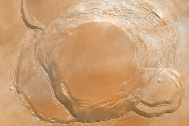
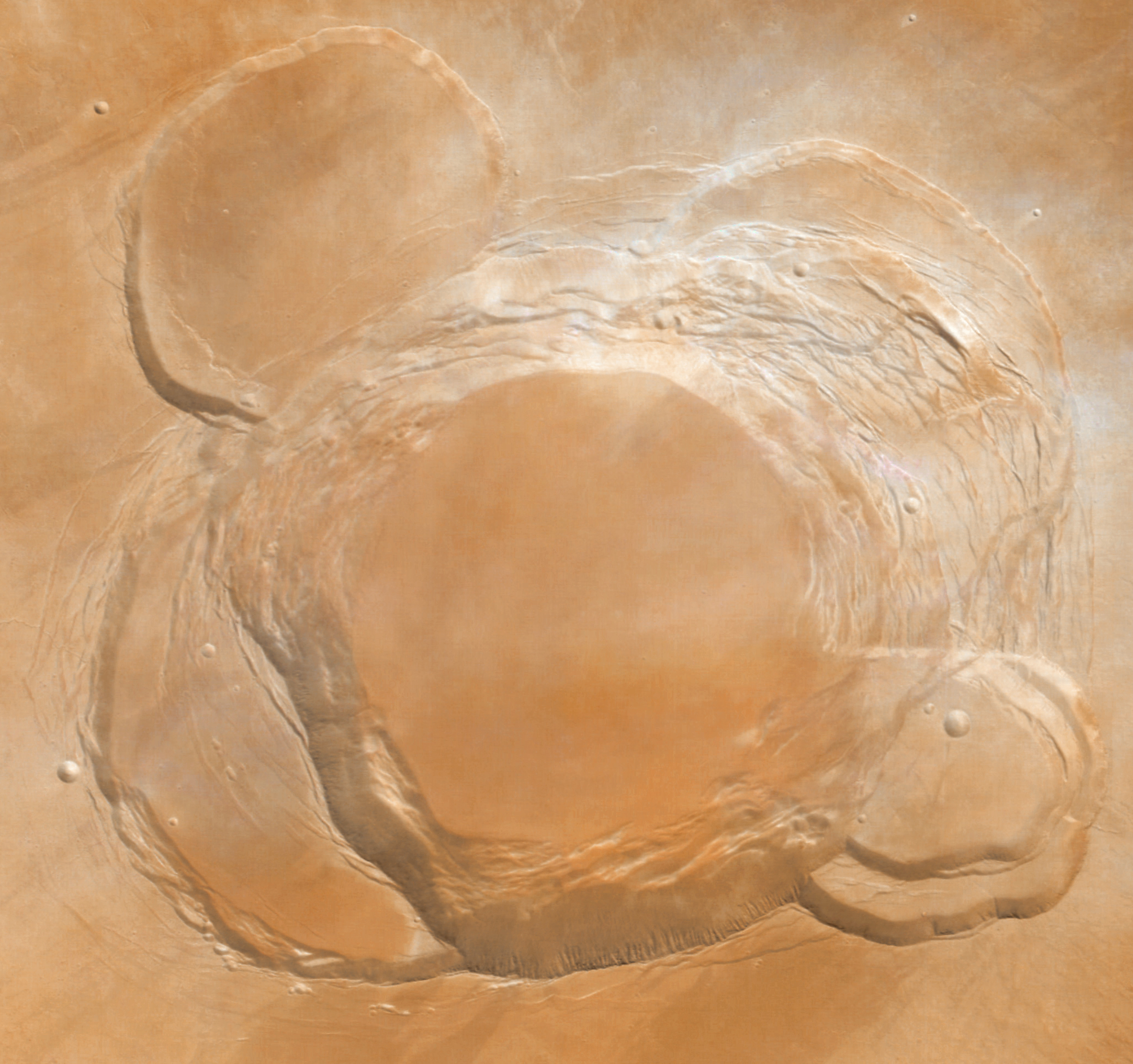
Ascraeus Mons is the northernmost of three shield volcanoes (known as the Tharsis Montes) near the equator of Mars. Its complex caldera (volcanic crater) is composed of several discrete centers of collapse where the older collapse features are cross-cut by more recent collapse events. The lowermost circular floor preserves the last lava flooding event that followed the last major collapse approximately 100 million years ago. The southern wall of the caldera has at least 3 km of vertical relief with an average slope of at least 26ยบ (from horizontal). The caldera complex truncates several lava flows, indicating that the flows predate the collapse event and that their source areas have been destroyed by the caldera formation.
This image was taken by the High Resolution Stereo Camera (HRSC) on board ESA’s Mars Express spacecraft and has not yet been officially released by ESA.

Image Credit: ESA/DLR/FU Berlin (G. Neukum)/astroarts.org

mex_ascraeus_mons_caldera_2

The complex caldera at the summit of
Ascraeus Mons.

This vertical view shows the complex caldera at the summit of Ascraeus Mons. North is at the top.

Image Credit: ESA/DLR/FU Berlin (G. Neukum)/astroarts.org

mex_ascraeus_mons_caldera_3

Perspective view of the caldera at the summit of
Ascraeus Mons.

This perspective view shows the complex caldera of Ascraeus Mons.
The vertical exaggeration is 1,5. North is up.

Image Credit: ESA/DLR/FU Berlin (G. Neukum)/astroarts.org

May
06

Amazonis Planitia

Posted under Exploring MarsViking Orbiter
viking1orbiter_amazonis_planitia_color

Viking Orbiter colour image of Amazonis Planitia.

This scene covers the boundary scarp between the ancient cratered highlands and the northern plains of Mars. The sedimentary deposits north of the highlands may consist of pyroclastic rocks or paleo-polar deposits. Ancient river channels cut the cratered highlands.
The region is a potential landing site for a future Mars mission.
North is 107 Deg clockwise. Image resolution is about 835 m/pixel.
Colour composite of the Viking 1 Orbiter images f690a02 (violet), f690a06 (green) and f690a08 (red), taken on May 8, 1978. The composite was processed further to show the approximate natural colour appearance of Mars.

Image Credit: NASA/JPL/Arizona State University/Image processing by astroarts.org

May
03

Clouds Around Olympus Mons

Posted under Exploring MarsViking Orbiter
viking1orbiter_olympus_clouds

Clouds around the summit of Olympus Mons.

This mosaic of six Viking 1 Orbiter images of Olympus Mons, taken on July 31, 1976, from a distance of 8.000 km, shows the volcano’s flanks and complex caldera protruding above thin clouds of water ice. The top of the cloud blanket is about 19 km above the mean ground level and 8 km below the summit. Parts of the cloud cover have a cellular appearance, indicating convection within the clouds. A well-developed wave cloud several hundred kilometers long is visible towards the limb.

Image Credit: NASA/JPL/Arizona State University/Mosaic by astroarts.org